Sunday, October 31, 2010

Site/Program Mapping

Having chosen my site, I began to take a look at how the program I have been leaning towards will fit with the location. As a reminder, I had first looked at the market/souq type, geared specifically towards the migrant workers' needs and economic means. A quick study of the locations of laborer housing and existing souqs was a primary generator for choosing my current site.

In conjunction with the souq type, I also was leaning towards a public social (potentially religious) space. As my site is directly adjacent to a parking lot that is used by workers for weekend cricket tournaments, I was leaning heavily towards the addition of a mosque rather than a public activity space (these choices were delineated in Methodology 3).

Thus, the below map of mosque locations overlaid on the previous mappings to understand whether this addition might be suitable for the location:


While this had initially been intended as a more site specific map, I found it interesting that the mosque locations favored the trend line I had identified in my first mapping. I included a 5-minute/quarter-mile walking radius in light green (as well as a circle with a radius half that for summer) to get an idea of how these mosques might work within their neighborhoods. There are very few mosques in the southeastern half of the city, in some parts of the city averaging less than one mosque per super-block. The nearest one to my site is within what is the equivalent of a gated community, so I question how easy it would be for workers to gain access to. Thus, I think a mosque is an appropriate programmatic addition to this project.

Thursday, October 28, 2010

Precedent #2: Souq Najada

Similar to (and across the street from) Souq Waqif, this souq exhibits an interesting combination of mosque and market within one complex. This is a programmatic combination that I will be looking into further in the next few days as I try to understand the shape that my program will be begin to take. Additionally, the wind tower is of interest environmentally, though this particular example has unfortunately been sealed off and conditioned now.


Monday, October 18, 2010

Site Selection

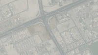
Following the site criteria outlined in the previous post, two sites come to the fore that are easily reached on foot from a migrant workers' housing area, are on/near the median line, and would make any project built there quite visible. Both are located on the northeastern end of al-Waab Street, the majority of which defines the median line.


Al-Waab St is a very wide arterial street added to Doha's streetscape to act as a processional axis during the 2006 Asian Games. Al-Waab terminates at the Aspire Sports Complex, which also includes a large park and a mall, the Villagio, both in blue as major public areas in the initial mapping. The street is defined by its unique streetlights, specifically designed to highlight the street literally and figuratively for the Asian Games.


Due to the difficulty (if not danger to life and limb) in crossing al-Waab Street due to heavy vehicular use, I stuck to sites on the southern side, near to the workers' housing area.


Two potential sites are mapped here, one much larger site and a second smaller site broken into two corner lots a block farther down al-Waab. The sites are highlighted in light blue (Villagio and Aspire Park are in the darker tones).


 The first site is located at the very end of al-Waab Street, where it turns into the previously existing street fabric. There is existing construction on site that may be problematic for further development.

It is a very large site with the added bonus of being the closer of the two to the migrant workers' housing. Also, as can be seen from the map above, the site is located next to a major Friday worker's area- in this case, the parking lot of Doha's premier football (soccer) club's stadium, weekly used for round-robin cricket tournaments (zoom in to the picture below).


The second site is much smaller, and is about a block longer walk from the workers' housing, but has the advantage of two corner lots that may be able to be developed in tandem.


While the two corner lots could make for an interesting condition to work with, the volume of traffic in the intervening street (zoom into aerial at right) may nullify any benefit, especially if the program is leaning towards a pedestrian emphasis.


While the two sites have their respective benefits, the first seems to me to be pretty obviously the more attractive one to work with, both for reasons of scale and proximity to housing and a Friday area. Existing development may have progressed quite a bit since this aerial was taken, so a back up probably isn't a bad idea.

Understanding Site: Worker's Housing

While the previous map seems to suggest the city is split a little too cleanly between an upper-class north and a working-class south, I next sought to map exactly where, as best I could discern, the migrant laborers lived.

While the area of the city south of the 'median line' plotted in the last mapping does contain all of the laborers' housing, much of the area is filled with gated villa communities. The majority of the migrant workers live off of this map to the southwest in a large complex known as the Industrial Zone. The map below shows a street-adjusted median and also includes the most heavily populated Friday worker's areas defined in the previous map.


In looking for a site, I sought three main qualities- first, that it be within walking distance to at least one of the worker's housing areas; second, that it be within reasonably close proximity to the median line to potentially draw non-laborers to the site; and thirdly, in a similar vein to the second, that it be a more or less visible site, likely located on a major road, rather than tucked within a neighborhood. This can help to attract people, whether laborers or not, to the site from cars or from greater distances.

On a different note, Souq Najada (in blue) was also included on this map (zoom into the crook in the median line). This is because while it is used by tourists, albeit to a lesser extent than neighboring Souq Waqif, it is more open to workers. There may still be some problems with allowing workers in on Fridays, though this is much more difficult to enforce due to the souq's inclusion of a mosque within the complex. Here migrant workers and Qataris alike will go to pray if nearby at any given prayer time. So as not to interfere with the souq's success among the laborers, I will likley place my project farther out in the city, in the intermediate workers' housing area. Sites on this boulevard, al-Waab St will be explored shortly.

Wednesday, October 6, 2010

Precedent #1: Souq Waqif

A first pass at analyzing Souq Waqif as the first in the 'market' type. Sections look at environmental conditions and/or mediation as well as use to a lesser extent.


Sunday, October 3, 2010

Mapping : Major Public Spaces & Friday Worker's Areas

 Major public areas such as parks, malls, souqs, and mosques center around the Corniche while laborers appropriate areas around Grand Hamad Street and Souq Najada- directly adjacent to major tourist or 'family' areas.


Zooming out, there seems to be a trend within the habitation of the city which sees wealthier Qataris, expats, and diplomats becoming more prevalent as one moves north towards West Bay while worker's areas and housing becomes more common as one moves south towards the industrial zone. A red meridian is drawn largely along Al Waab Street that seems to suggest the turning point of this trend.

Revised Methodology


Moving forward, I am now shifting towards precedent studies and mappings. Based on the information gleaned from these, I will be able to more intelligently pick my site and develop the program of my proposal.

Proposal : Public Space for Migrant Workers in Doha

Based on my own experience and backed up, albeit in a more dramatic fashion, by news articles* such as Peter Townson's 'Souq shock' piece for the Gulf Times, there is a noticeable absence of Doha's majority class of migrant workers in public spaces around the city. Accepting that a single urban intervention, whether large or small, likely will not change the structure of a society simply through the act of its creation, I propose to create a public urban space that fulfills the needs of migrant workers in Doha for a societally acceptable zone of leisure activity that also addresses environmental conditions as well as the unique economic and urban conditions specific to the labor class. While not explicitly engaging in either polemical or utopian debates by attempting to integrate the wealthiest and poorest members of Qatari society in one stroke, I believe that the selection of a site for the proposal outlined below will allow me to address the disparity between classes in the occupation of social space in at least an oblique or associative manner.

In focusing on the migrant worker class in Doha, three main issues emerge immediately that will inform the programmatic and architectural development of the project as it moves forward- economics, the social (here not synonymous with sociopolitical) element, and climate. The first two are indicative of the labor class- as migrant workers, the majority are in Doha to earn higher wages than was possible in their home countries, with the intent of sending the majority of their earnings back home to their families. As such, there is little disposable income left for these men and women to spend beyond necessities of living (food or cell phone minutes, for example). Secondly, there is a current trend of appropriating public areas such as parking lots or specific sidewalks near banks or outside other public venues on Fridays (the laborers' day off) as a means for the labor population to socialize away from their housing blocks or places of work.

Workers congregating beneath the sculpture on Grand Hamad St. on a Friday.
 The last issue, that of climate, hardly needs explanation, though it is necessary to point out that, as it stands, with laborers largely barred from malls and other large-scale public leisure venues, their are few options for recreation on Friday afternoons in the summer months.

Taking these three issues into consideration, I am proposing to design an outdoor market and social area specifically for migrant laborers that takes full advantage of passive cooling methods such as shading and natural ventilation with the aim of creating a space that can be used year round. The market area will supply the workers with a venue to buy non-grocery necessities or less tourist-oriented items of interest, while a larger public social space such as a playing field or a mosque will meet the need for a large space for the workers to congregate and socialize without blocking whole blocks of sidewalk or appropriating whole parking lots or small green spaces. Finally, by taking advantage of passive cooling techniques, this project can address the need of the labor class for a summertime social venue while setting an example for the city as sustainable initiatives gain momentum.

  
*Note: The article cited above and similar sources are reporting from 2008. When I visited in 2010, there was a noticeable absence of laborers in the more tourist- or family-oriented souqs, though there were no violent altercations between workers and security.